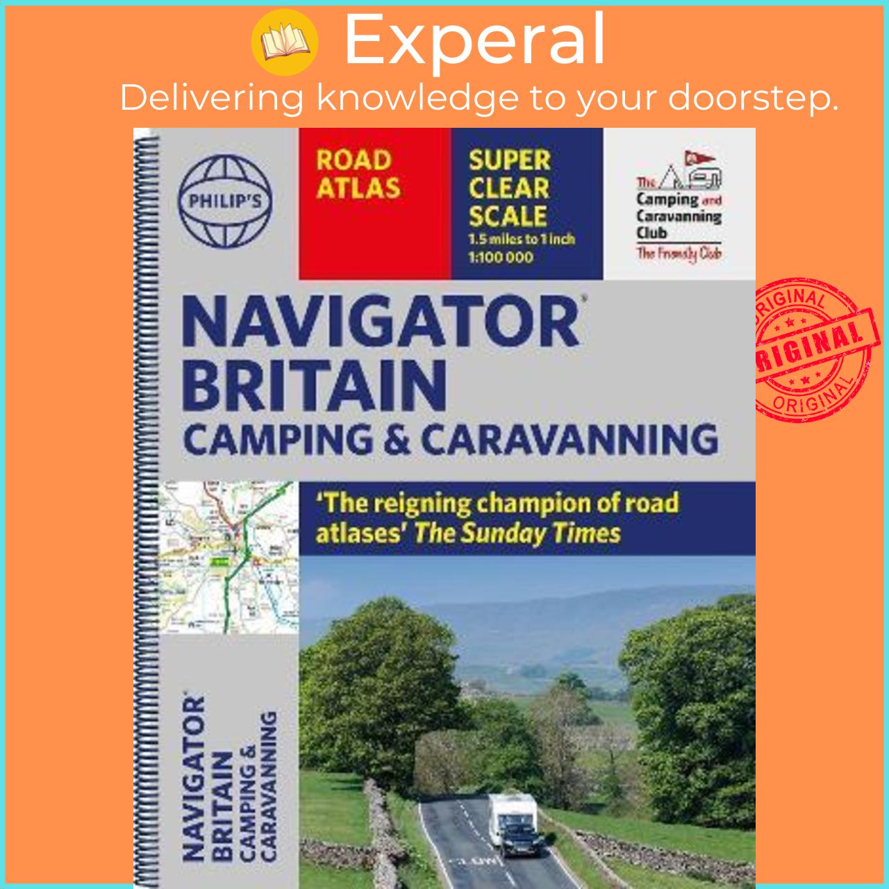
Sách - Philip's Navigator Camping and Caravanning Atlas of Britain by Philip's Maps (UK edition, paperback)
Ships from and sold by EXPERAL Singapore Publisher: Octopus Publishing Group Origin: United Kingdom (Imported) ISBN 13: 9781849076289 Condition: Brandnew Binding: paperback Pages: 416 Dimensons: 346 x 282 x 22 | 1960 (gram) ---------------------------------------- THE

Experal
@experalĐánh giá
Theo Dõi
Nhận xét


Ships from and sold by EXPERAL Singapore Publisher: Octopus Publishing Group Origin: United Kingdom (Imported) ISBN 13: 9781849076289 Condition: Brandnew Binding: paperback Pages: 416 Dimensons: 346 x 282 x 22 | 1960 (gram) ---------------------------------------- THE MUST-HAVE ATLAS OF BRITAIN FOR CAMPING, CARAVANNING AND MOTORHOMES 'A map that beats all others' - The Daily Telegraph 'Scale, accuracy and clarity are without parallel' - Driving Magazine 'No. 1 in the UK for clear maps' - Independent research survey The lure of the open road and British countryside has never waned and the appeal of independent exploration has surely grown in recent years. However, the adventurous need practical information about what lies ahead - from bridge heights, widths and weights to places to stop and enjoy. Philip's Navigator Camping and Caravanning Atlas of Britain is the No. 1 Choice of Road Atlas for the independent travelling motorist and camper van owner. * Scale: 1.5 miles to 1 inch = 1:100,000 (Northern Scotland: 3 miles to 1 inch = 1:200,000) * Over 1,880 approved campsites located, plus essential advice from The Camping and Caravanning Club * Includes essential information for caravanning motorists: 6000 bridge height limits, 1500 bridge weight limits and 260 bridge width limits - No other road atlas of Britain offers this level of detail and clarity - Britain's best road mapping in a great spiral format - Every street in Britain is marked on the maps - Over 3000 main roads named - 100 indexed town-centre maps plus approaches to 12 major urban areas - Super-detailed 6-page route-planning section - Exceptional road detail, from motorways to country lanes, with every junction, roundabout and slip-road shown - Thousands of individually named farms, houses and hamlets Philip's Navigator Camping and Caravanning Atlas of Britain includes a special feature by The Friendly Club, which is packed with essential camping and caravanning information. Giá sản phẩm trên Tiki đã bao gồm thuế theo luật hiện hành. Bên cạnh đó, tuỳ vào loại sản phẩm, hình thức và địa chỉ giao hàng mà có thể phát sinh thêm chi phí khác như phí vận chuyển, phụ phí hàng cồng kềnh, thuế nhập khẩu (đối với đơn hàng giao từ nước ngoài có giá trị trên 1 triệu đồng).....
Công ty phát hành
Penguin Books
Nhà xuất bản
Penguin
ISBN-13
9781849076289
Sản Phẩm Tương Tự


Sản Phẩm Liên Quan

Xiaomi Mijia Đèn Ngủ Cảm biến ánh sáng Tiết Kiệm Năng Lượng (Trắng)
146.000₫
Đã bán 29


Đồng hồ báo thức thông minh bluetooth Xiaomi Youpin, kiểm soát độ ẩm và nhiệt độ, màn hình LCD
296.000₫
Đã bán 2